Image
Snow predictions
As a major winter storm intensifies its approach towards the Northeast, projections for snowfall totals have escalated, adding an extra layer of concern for residents just before Valentine's Day. Meteorologists now anticipate a more substantial accumulation of snow, urging communities to prepare for potentially hazardous conditions. The revised forecast signals heightened expectations for snow-related disruptions, prompting local authorities to implement precautionary measures and residents to exercise caution during travel. With the storm's arrival coinciding closely with Valentine's Day, the region faces the challenge of navigating both the atmospheric disturbances and the potential impact on planned celebrations.
The National Weather Service has pinpointed the timeframe for the impending winter storm, forecasting its arrival from overnight Monday evening, February 12, through Tuesday afternoon, February 13. This specific window intensifies the urgency for residents and local authorities to make necessary preparations and closely monitor developments as the storm unfolds. The overnight nature of the storm raises concerns about visibility and road conditions during the morning commute on Tuesday, requiring individuals to exercise heightened caution and stay informed about potential disruptions.
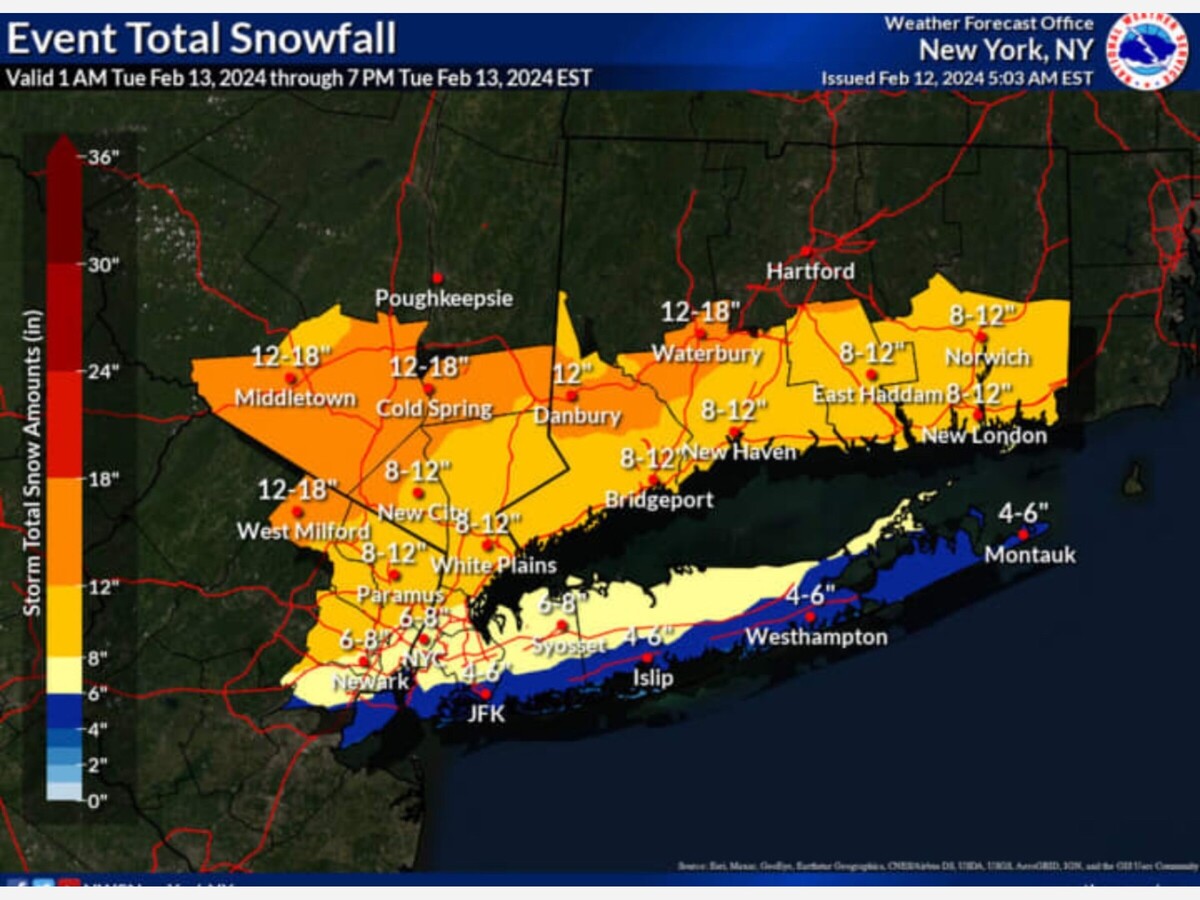
The updated snowfall projections for the impending winter storm indicate varying intensities across different regions. Westchester, Rockland, Fairfield, and New London counties are expected to bear the brunt with a widespread accumulation of 8 to 12 inches of snow. In contrast, much of New York City and northern Long Island are now forecasted to receive 6 to 8 inches, while downtown Manhattan and southern and eastern Long Island are anticipated to experience a milder impact with 4 to 6 inches of snow. These revised estimates underscore the need for residents in the specified areas to prepare for the anticipated snowfall and its potential impacts on daily activities and travel.
Further intensifying the winter storm's impact, updated projections highlight the potential for significant snowfall in specific regions. Putnam and Orange counties in the Hudson Valley, as well as parts of northern Fairfield, New Haven, and Middlesex counties in Connecticut, could now face substantial snow accumulation of up to 18 inches. This heightened estimate emphasizes the localized variability of the storm's impact, urging residents in these areas to take extra precautions and closely follow official updates as the situation evolves.
Anticipated precipitation dynamics indicate a transition from rain to a wintry mix on Monday night, with the changeover occurring a few hours before daybreak on Tuesday. In inland areas, heavy snowfall is expected, prompting the issuance of a Winter Storm Watch in effect from 1 a.m. to 6 p.m. on Tuesday. This timeline underscores the importance of vigilance during the overnight period and early morning hours, especially in the designated areas, as the storm intensifies, potentially causing challenging travel conditions and other weather-related impacts.
Adding to the weather dynamics, wind gusts are forecasted to reach as high as 30 to 40 miles per hour at the peak of the storm. This elevated wind speed raises concerns about potential blowing snow, reduced visibility, and increased likelihood of power outages, emphasizing the need for residents to secure loose items and take precautions during the storm's most impactful periods.
Leading up to the approaching storm, Monday's weather is expected to feature a mix of sun and clouds, accompanied by a relatively mild high temperature in the mid-40s. This transitional weather pattern hints at the atmospheric conditions preceding the wintry mix and snowfall, providing residents with a window of relatively milder conditions before the impending storm takes hold.
As the low temperature is projected to dip just below freezing overnight into Tuesday, a widespread mix of precipitation, including rain, sleet, and snow, is anticipated from the system. Inland areas, away from the coast, are expected to experience predominantly snow, at times heavy. This temperature-driven transition underscores the potential for varied and impactful weather conditions, urging residents to stay informed and prepare for the changing dynamics associated with the approaching winter storm.
The current outlook for Valentine's Day on Wednesday, February 14, indicates mostly sunny skies with a high temperature in the low to mid-30s. This forecast suggests a relatively clear and cool day, providing a contrast to the preceding winter storm. Residents can anticipate a calmer weather scenario on Valentine's Day, offering a chance to enjoy the day without the weather-related disruptions experienced earlier in the week.


Patchy rain nearby, with a high of 84 and low of 70 degrees. Patchy rain nearby during the morning, sunny in the afternoon, patchy rain nearby for the evening,