Image
A formidable storm system is set to traverse the Northeast, characterized by its complexity and strength. This weather event poses a significant threat of power outages, primarily attributed to the presence of destructive wind gusts. Furthermore, the region is at risk of flooding, as the storm brings heavy downpours, compounded by the simultaneous melting of snow. The combination of these factors heightens the potential for adverse consequences, urging residents and authorities to exercise caution and preparedness in the face of this impactful meteorological event.
The National Weather Service indicates that the upcoming storm will bring forceful winds across the entire region. The most perilous gusts, exceeding 65 miles per hour, are anticipated specifically on Long Island and along the coastal areas of New England. This heightened wind activity poses a considerable risk, requiring residents in these areas to take precautionary measures and stay informed about the evolving weather conditions. Be prepared for potential disruptions and prioritize safety in the face of these intense wind speeds.
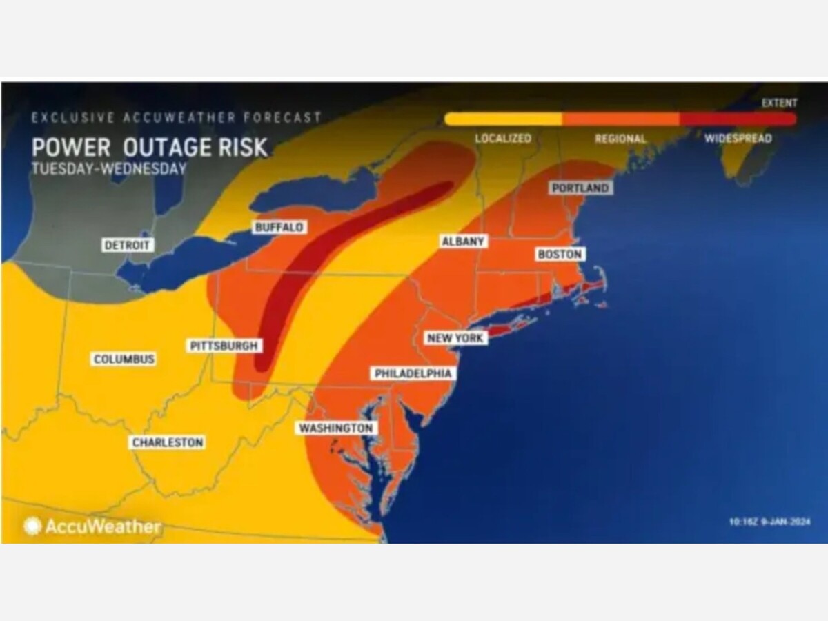
Regions highlighted in red on the AccuWeather.com image signify the highest risk zones for potential power outages. Stay informed and take necessary precautions if you are in these identified areas to mitigate the impact of the upcoming storm.
In New York, specific high-wind warnings are currently active, spanning from 6 p.m. on Tuesday, January 9, to 6 a.m. on Wednesday, January 10. This advisory encompasses Southern Westchester County and the entirety of Long Island. Additionally, in Connecticut, coastal areas are under the influence of these high-wind warnings during the same time frame. Residents in these regions should remain vigilant, adhere to local authorities' guidance, and take necessary precautions to ensure their safety during this period of heightened wind activity.
A significant weather scenario is unfolding, with a widespread expectation of 2 to 4 inches of rain. This precipitation, when combined with the melting snowpack and the ground already saturated from previous rainfall, significantly elevates the risk of flooding. The potential consequences include heightened water levels, increasing the likelihood of road closures. Residents in affected areas should exercise caution, stay informed through official channels, and be prepared for the possibility of disrupted travel due to flooding.
The critical period for the most severe flooding downpours and dangerous winds is pinpointed within a roughly four-hour window, spanning late Tuesday night into the early morning hours after midnight on Wednesday. Stay vigilant during this timeframe, taking necessary precautions to ensure safety in the face of the anticipated adverse weather conditions.
In an advisory issued Tuesday, the National Weather Service said to expect the following:


Patchy rain nearby, with a high of 84 and low of 70 degrees. Patchy rain nearby for the morning, sunny in the afternoon, patchy rain nearby in the evening,