Image
The Northeast is currently grappling with the onslaught of a massive winter storm, causing widespread snowfall and triggering a cascade of disruptions. The relentless snowfall has prompted school closures across the region, as authorities prioritize the safety of students and staff amidst hazardous weather conditions. Travel has become treacherous, with icy roads and reduced visibility posing significant challenges for commuters. Residents are urged to exercise caution and adhere to safety guidelines as the winter storm continues to unfold, impacting daily routines and underscoring the need for preparedness in the face of severe weather conditions.
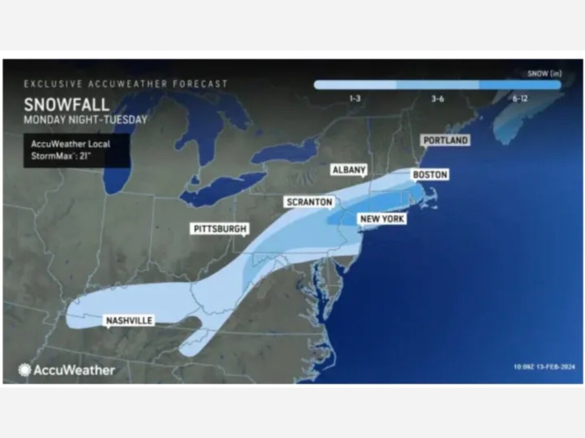
Overnight, a blanket of snow has enveloped much of the region, while southern coastal areas are anticipated to experience a mix of precipitation transitioning to snow after daybreak on Tuesday, Feb. 13, as indicated by the National Weather Service. This dynamic weather pattern underscores the complexity of the ongoing winter storm, with varying conditions across different areas. Residents are advised to stay informed about local weather updates, as the transitioning mix can contribute to changing travel conditions and snow accumulations. Vigilance and adherence to safety precautions remain crucial as the region navigates through the evolving impacts of this winter weather event.
The snowfall is anticipated to gradually taper off by mid-to-late afternoon, leaving a substantial accumulation across the region. According to AccuWeather.com's final projections released on Tuesday morning, widespread totals of 6 to 8 inches are expected. Additionally, some areas, indicated by the darkest shade of blue in the projections, may experience locally higher amounts, reaching a foot or more. This significant snowfall underscores the impact of the winter storm, prompting residents to exercise caution and plan accordingly as they navigate through the aftermath of the weather event. Stay updated on local advisories and weather conditions for a safer and informed approach to the day.
The National Weather Service highlights that the areas with the most substantial accumulation are likely to be where locally heavier bands of snowfall move through. This emphasizes the dynamic nature of the storm, with varying intensity across different regions. Residents should stay vigilant and be prepared for fluctuating conditions, as these heavier bands can contribute to localized accumulations exceeding the general forecast. As the winter storm unfolds, monitoring real-time weather updates and heeding official advisories remains essential for those navigating through the impacted areas.
As the winter storm continues its impact, a Winter Storm Warning is in effect for most of the Northeast until 6 p.m. Tuesday, as declared by the National Weather Service. Given the challenging travel conditions, authorities advise those who must travel to exercise utmost caution.
The National Weather Service recommends that individuals keep an extra flashlight, food, and water in their vehicles as precautionary measures in case of emergencies. These preparations are crucial to ensuring the safety and well-being of travelers amidst the ongoing weather challenges associated with this impactful winter storm.
Following the passage of the winter storm system, skies are expected to gradually clear after nightfall, bringing a respite from the turbulent weather conditions. The overnight forecast indicates a low temperature in the mid-20s, accompanied by lower wind-chill values. While the storm's departure signals improving weather, residents are urged to remain cautious of potentially icy conditions and dress accordingly to mitigate the impact of lower wind-chill values. Stay informed with local weather updates for a safer transition as the region moves beyond the immediate effects of the winter storm.
Valentine's Day on Wednesday, Feb. 14, is expected to bring sunny yet brisk conditions to the region. Anticipate high temperatures in the low to mid-30s, coupled with wind-chill values ranging from the teens to the 20s. While the sunshine will add a cheerful touch to the day, residents are advised to dress warmly and be mindful of the brisk conditions, ensuring a cozy and enjoyable Valentine's Day celebration. Stay updated with local weather forecasts for a delightful and comfortable experience on this special day.


Patchy rain nearby, with a high of 84 and low of 70 degrees. Patchy rain nearby during the morning, sunny in the afternoon, patchy rain nearby for the evening,